Friday, December 9, 2011

Chapter 18: Hawaii

Although separated from the mainland of the United States, Hawaii continues to have very strong to the rest of the country. This is in part due to the significant presence of the federal government in the state. According to government records, in 2010 the federal government employed nearly 35,000 people. Of these, approximately 18,500 worked for the United States Department of Defense.

The Department of Defense has a very large presence on the Hawaiian Islands. This includes Fort Shafter, Pearl Harbor Naval Air Station, Barbers Point Naval Air Station, Hickam Air Force Base and the Fourteenth District Coast Guard. It is also home to the United States Pacific Command Center.
United States Pacific Command Center


Sources: http://www.civilbeat.com/topics/federal-government-in-hawaii/
http://www.avsinc.net/imgs/pictures/coc-case-study.jpg
http://usmilitary.about.com/library/milinfo/statefacts/blhi.htm

Chapter 16: The North Pacific Coast

The North Pacific Coast region is well known for it's rugged mountains, lush forested areas and heavy rainfall. Due to the physical environment, the fishing and lumber industries have thrived in this area of North America. In contrast, Washington D.C. does not have the heavy industry that the North Pacific Coast region is known for, nor does it have the rugged, forested landscape that makes up a large portion of physical environment.

What it does have in common is a fair amount of precipitation. Although, the heavy amount of rainfall that the North Pacific Coast experiences is far greater. D.C.'s precipitation occurs year round, with the heaviest months in late spring and summer. May is at the top of this list, with 4 inches of rain. In contrast, Seattle experiences nearly 6 inches of rain in their wettest month, November. But comparing the two cities shows that in May-September, D.C. bests Seattle in the area of rainfall, as this is the typical dry season for the area.

Source: http://www.clrsearch.com/Demographic?state_id=349357&city_id=281472&place=Washington%2C+DC+20037&state=District+of+Columbia&chart=weatherprecip


Sources: http://www.weather.com/weather/wxclimatology/monthly/graph/USDC0001
 http://www.weather.com/weather/wxclimatology/monthly/graph/USWA0395

Chapter 15: California

There is no denying the fact that California, particularly the Los Angeles area, is the capital of tv and movie production in the United States. With studios such as Paramount, 20th Century Fox, Warner Brothers and Universal based in the area, it is the first choice for many filmmakers to base their operations.
However, with Washington D.C. being the capital of the U.S., it's location is the basis for many television shows and movies each year. With such important and historical backdrops such as the White House, the U.S. Capitol building, F.B.I Headquarters and the National Mall, it is no wonder that many political based shows and movies choose D.C. as their primary filming location.
The following is a list of just some of the t.v. shows and movies that have been filmed in the D.C. area:
  • Mr. Smith Goes to Washington
  • In the Line of Fire
  • Spy Game
  • JFK
  • The Exorcist 
  • The X-Files
  • Bones
  • NCIS
  • Homeland 
Source: http://en.wikipedia.org/wiki/Category:Films_shot_in_Washington,_D.C.

Source: http://www.onlocationvacations.com/wp-content/uploads/2010/10/t31.jpg

Chapter 14: The Southwest Border Area: Tricultural Development

The Southwest Border area is home to the larges population of Latinos and Native Americans in the United States. Although both populations are scattered across the whole of the country, this has become the largest area of settlement due to the proximity of both large Native American reservations and the U.S. border with Mexico.
Museum of the American Indian
Source: http://www.paulridenour.com/hagers63.JPG


Washington D.C. contrasts with the Southwest Border Region in this area. According to the United States 2011 Census, only .3% of the population of D.C. are Native Americans. In addition, only 9.1% of the the population are Latino or Hispanic. The largest population of the area being African Americans at 50.7%, followed by Whites at 38.5%. The distance from reservations and the Mexican border are great contributors to these numbers.
Source: http://www.gracemeridianhill.org/site/wp-content/uploads/2011/10/dc_latin_origin_r12.jpg

Chapter 13: The Empty Interior

The Empty Interior is home to over 30 National Parks, both from the United States and Canada. Although no other area of the United States can compare to that number, there are a significant number of National Parks that lie outside of that area.

Shenandoah National Park is the closest of these parks to the Washington D.C. area. It lies approximately 75 miles SW of the D.C. city limits. Shenandoah National Park covers nearly 80,000 acres and it's highest peak is Hawksbill Mountain, which reaches a height of 4,051 feet. (Source: http://en.wikipedia.org/wiki/Shenandoah_National_Park).
Source: http://0.tqn.com/d/gosoutheast/1/0/n/N/-/-/shen_nps_500.jpg
Also, like the Empty Interior, Washington D.C. is a magnet for tourism. People from all over the county (and world) come to the area to visit the capital of the United States. There are various monuments, museums and historic sites that see large amounts of visitors annually. Tourist season generally ranges from April to September, avoiding the chilly winters and taking advantage of the warm spring season. In 2010 there were 15.4 million visitors to the district, including 1.75 foreign visitors. (Source: http://washington.org/planning/press-room/corporate-and-convention-info/research-and-statistics)
Source: http://www.michelintravel.com/_uploads/2011/09/Must_Sees_WashingtonDC_Cover-600x1024.jpg

Chapter 12: The Great Plains and Prairies

Washington D.C. is very different from the Great Plains, especially the physical environment. Whereas the Great Plains hold vast amounts of flat, open space, the D.C. area is quite the opposite. Although there are only slight elevation changes within the D.C. city limits, there are a large amount of trees and other vegetation. The parks that I previously mentioned are a prime example of this.

Just outside the D.C. area are the lush, forested areas of Virginia, West Virginia and Maryland. These areas include various elevation changes due to the mountainous areas of land in which they lie. Within these states are situated various National Forests and Shenandoah National Park.
Source: http://www.outdoorbasecamp.com/new/wp-content/uploads/2010/07/Shenandoah_National_Park.jpg


Significant rainfall and extreme weather is present in both the Great Plains region and Washington D.C. Although, the tornadoes of the Great Plains are replaced by blizzards and the occasional hurricane in the D.C. area.
Source: http://upload.wikimedia.org/wikipedia/commons/7/71/Blizzard_12_2009_Arlington_DC_8258.JPG

Friday, October 28, 2011

Chapter 11: The Agricultural Core

Washington D.C. is far from the heartland of America. It is not an agricultural city by any means, it is a large metropolitan city with no vast stretches of farmland. However, D.C. is very important to agriculture in that it is the headquarters for the United States Department of Agriculture.
 The USDA began as a division of the US Patent Office. It's main duties were to collect statistics on agriculture and to serve "other agricultural purposes."It was not until 1862, that President Lincoln established the USDA as its own autonomous agency. The USDA has served many purposes over the years. It has helped teach agriculture and home economics to the public, helped to ensure that food was being produced and distributed during the Great Depression, assisted with loans for landowners, and has helped to provide education on proper nutrition.
Source:http://thesocietypages.org/graphicsociology/files/2009/06/food_pyramid_usda_old.png


Chapter 10: The Southern Coastlands: On the Subtropical Margin

Washington D.C. shares two major characteristics with the Southern Coastlands.

First, it also has a subtropical climate. Subtropical climates are generally characterized by long, hot, humid summers. In Washington D.C., summer temperatures range from the uppers 70s in late May, to the upper 80s in August. It is not uncommon for there to be heat waves, where the temperature can easily climb into the 90s and 100s. Humidity adds to the discomfort of the heat. Average July humidity is around 66%. (Source: http://en.wikipedia.org/wiki/Washington,_D.C.#Climate)
Source: http://pics2.city-data.com/w1q/lhaq3714.png
Second, Washington D.C. is also prone to hurricanes. Although usually not nearly as strong as those that hit the Southern Coastlands, hurricanes have been known to hit D.C. These hurricanes are generally the weak fallout of larger storms and hit anywhere from late summer to early fall. They have, on occasion, been fairly strong.
Source: http://media.nationaljournal.com/?controllerName=image&action=get&id=10927

Sunday, October 16, 2011

Chapter 9: The Changing South

Washington D.C. is located outside of the Southern region of the United States, however it does have one of the largest populations of African Americans in the country. Of the approximately 600,000 people living within the city limits, more than half (52.7% or 315,968) were African American.
Source: http://pics.city-data.com/craces2/3714.jpg


Again, although not in the South, Washington D.C. does have a history of slavery. 10 of the first 15 presidents were slaveholders, including George Washington, James Madison and Andrew Jackson. Slaves were used in such positions as cab drivers, barbers and hotel staff. In fact, on the day Abraham Lincoln was inaugurated in 1861, there was a slave auction less than 5 miles away from the capitol. (Source: http://opinionator.blogs.nytimes.com/2011/02/24/a-capital-under-slaverys-shadow/?partner=rss&emc=rss)
Source:http://graphics8.nytimes.com/images/2011/02/24/opinion/disunion_goodheart_25capitol/disunion_goodheart_25capitol-popup-v2.jpg


Saturday, October 15, 2011

Chapter 8: Appalachia and The Ozarks

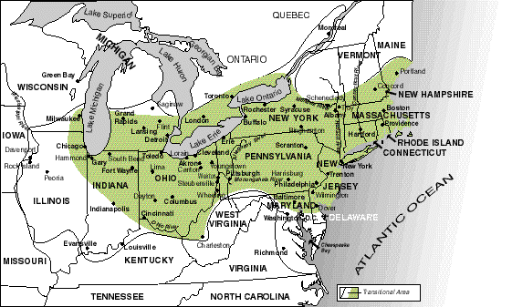
Washington D.C. is located outside of the Applachia and Ozarks regions, however some of the Appalachia region does spread into the surrounding states of Maryland, Virginia and West Virginia.

As for the city itself, Washington D.C. is rather flat. The highest point in the city is only 420 ft. above sea level. Within the city there are a few natural areas which have remained undeveloped, the largest of which is Rock Creek Park.
Source: http://www.nationalparks.org/images/PlanYourParkTripimgs/parkgraphics/ROCR.jpg
Rock Creek Park is a 1,754 acre natural area which is located within the D.C. city limits. The park was established in 1890 and is under the care of the National Parks Service. It is used by city dwellers for various recreational activities including jogging and cycling.

Source: http://www.cityprofile.com/forum/attachments/district-columbia/8042-washington-anacostia_park2.jpg
Anacostia park is another large natural area located in the D.C. area. The park covers approximately 1,200 acres and is also under the care of the National Parks Service. Some of the activities the park is used for include boating, baseball, jogging and picnicking.

Unlike the Appalachia region, Washington D.C. does not suffer from the extreme levels of poverty found in some Appalachian areas. The median household income in 2009 was $58,906, which is about $8,000 above the national average. Source: http://quickfacts.census.gov/qfd/states/11000.html

Chapter 7: The Bypassed East

Washington D.C. is not located in the area known as the Bypassed East, which is the Atlantic Provinces of Canada, Northern New England and the Adirondack region of New York. In addition, it does not share many similarities with the region.

Source: http://www.majorleaguesoccertalk.com/media/2009/05/dc-metro-area.jpg
In contrast to the sparse population centers of the Bypassed East, Washington D.C. is considered to be one of the major metropolitan areas of the United States. There are over 600,000 people within the city limits, and over 5 million in the metropolitan area. The D.C. metropolitan area is made up of two divisions, Washington and Bethesda (Md). The makeup is as follows:

Washington: D.C., Arlington and Alexandria-this includes the DC, Va, MD and WV metro division.
Bethesda: Bethesda, Frederick and Gaithersburg-this includes both Frederick and Montgomery counties.

Also unlike the Bypassed East, Washington D.C. is relatively flat. The highest point in the city is 420 ft. above sea level. To find mountainous terrain, one must travel outside of the city limits to areas in surrounding Maryland, Virginia or West Virginia.

Friday, September 30, 2011

Chapter 5: The North American Manufacturing Core

Washington D.C. is located in the North American Manufacturing Core. This area is located in the Northwest of the United States and is concentrated in the Ohio River Valley, Megalopolis and Great Lakes areas.

Source: http://aboutusa.japan.usembassy.gov/gifs/wwwg-jusa-geo-map04.gif
The district is actually located in the outskirts of the manufacturing core and little manufacturing is actually done within the city limits. In 2004 only 3.9% of all jobs in the city were in the manufacturing field. That number is expected to drop to 2.8% by 2015. (source: http://www.city-data.com/us-cities/The-South/Washington-D-C-Economy.html). 


Source: http://www.copycatprintshop.com/Graphics/bind.jpg
The industries that dominate the D.C. area are paper (there are over 500 publishing/printing companies in the district), telecommunications, information technology, computer, tourism and hospitality firms. In addition, with over 100 million square feet of office space and the fact that D.C. is the capitol of the United States, the concentration of government and government related operations is unmatched in the country.

Chapter 4: Megalopolis

Washington D.C. sits in the original Megalopolis, as described by geographer Jean Gottman in 1961.

The Megalopolis is an the area of the East Coast of the United States (from Washington D.C. to Boston) noted for its large population agglomeration (Approx. 50 million people).

Megalopolis.
Source: http://usa.usembassy.de/etexts/outgeogr/map3.gif
The region accounts for 20% of the U.S. Gross Domestic Product. The region is home to the New York Stock Exchange and NASDAQ, the White House and United States Capitol, the headquarters of the United Nations, and the headquarters of ABC, NBC, CBS, Fox, the New York Times Company, USA Today, and The Washington Post. The headquarters of many major financial companies—such as State Street, Citigroup, and Fidelity—are located within the region, which is also home to 54 of the Fortune Global 500 companies. The headquarters of 162 of the Fortune 500 are in the region. The region is also the center of the global hedge fund industry, with 47.9% of $2.48 trillion of hedge fund assets being managed in its cities and suburbs. Similarly, the majority of the global private equity, venture capital, investment banking, and management consulting industries are centered and/or headquartered in this region.
Source: http://en.wikipedia.org/wiki/Northeast_Megalopolis


One reason Washington D.C. is part of this Megalopolis is the fact that it is easily accesible by navigable waters. It's proximity to the Potomac river, and in turn Chesapeake Bay and the Atlantic Ocean. This opens up major options for trade and commerce, with the international community as well as the other Megalopolis cities, which are all linked by  Interstate 95 and US Route 1.


Another important reason is due to the fact that Washington D.C. is home to all major government operations. This includes the White House, Capitol, Supreme Court, Pentagon and FBI.

Saturday, September 24, 2011

Chapter 3: Foundations of Human Activity

Historical
Washington D.C. is situated in the region first occupied by the Nacotchtank and Piscataway tribes around 4,000 years ago. These tribes were first recorded by English settlers in the early 1600s.
Nacotchtank people with European Settlers (17th Century)
Source: http://www.realtrnva.com/files/159691/people%20having%20a%20meeting.JPG
European settlers would continue to grow in the region, eventually founding present day Georgetown in 1751. After deciding to move the capital of the United States from Philadelphia, an area of land in Maryland was chosen as the new location. This area is know known as Washington D.C. Sites in Virginia, New York and New Jersey were also considered.

Present Day Demographics

Population: 601,723

Population Density: 9,800/sq. mi.

Ethnic Data: 50.7%-African American, 38.5% White, 9.1% Hispanic, 4.1% Other, 3.5% Asian, 0.3% Native American.
  • Major sources of immigrants living in Washington D.C. include Vietnam, Ethiopia and El Salvador.
  • Population of African Americans living in D.C. has decreased due to movement into suburbs, while the White population has been steadily increased due to Gentrification.
Ethnic Makeup of Washington D.C.
Red-White, Blue-African American, Green-Asian, Orange-Hispanic, Gray-Other
Source: http://www.flickr.com/photos/walkingsf/4981417821/
Other Data

Religion
  • Christian-28% Catholic, 9.1% American Baptist, 6.8 % Southern Baptist, 1.3% Eastern/Oriental Orthodox, 13% Other.
  • Non-Christian: 10.6% Islam, 4.5% Judaism, 
  • Other/Non-Practicing: 26.8%
Sexuality
  • According to the 2000 census, 8.1% of the population labeled themselves as Gay, Lesbian or Bisexual.
Income
  • Median household income in 2009 was $59,290. (Source: http://www.city-data.com/city/Washington-District-of-Columbia.html)


Chapter 2: Geographic Patterns of the Physical Environment

Elevation
The elevation of Washington D.C. ranges from sea level at its lowest point, to 410 ft. above sea level at its highest. These areas are the majority of the shores of the Anacostia and Potomac rivers and Fort Reno, respectively.

Fort Reno
Source: http://dcist.com/2007/05/31/fort_reno_2007.php


Water Bodies
Washington D.C. contains three major natural bodies of water. The Potomac River, Anacostia River, and Rock Creek.

Potomac River
Source: http://ispythingsdc.com/wp-content/uploads/2010/04/potomac1.jpg
Climate
Washington D.C. is located in the humid subptropical (Cfa) climate region.

The District experiences four distinct seasons:

  • Winter-Cold. Highs in the low to mid 40s. Lows in the upper to low 30s
  •  Spring-Dry and sunny. Highs in the mid 50s to upper 60s. Lows in the upper 30s to upper 40s.
  •  Summer-Hot and humid. Highs in the low 80s to mid 90s. Lows in the upper 60s to mid 70s.
  •  Fall-Dry and sunny. Highs in the upper 70s to upper 50s. Lows in the low 60s to low 40s
Rainfall: Spread throughout the year, with average yearly precipitation rate of 39.5 inches.

Snowfall: Usually occurring in January and February, with average yearly snowfall of 14.7 inches.

Soil Type: Piedmont material, Coastal Plain sediment and recent alluvial sediment. (Source:http://www.sawgal.umd.edu/nrcsweb/DCsoils/index.htm)


Monday, September 19, 2011

Chapter 1: Regions and Themes


Area: 68.3 sq mi
Elevation: 0-409 ft
Population: 601,723
Population Density: 9,800/sq mi

Washington D.C. is an autonomous district located on the East Coast of the United States in between the states of Maryland and Virginia. It serves as the capital of the United States.